Winter Backpacking - Rush Ridge to Hansons Point
Table of Contents
| The Full Trail | |
|---|---|
| Date | 12/5/2025 |
| Distance | 4.52 mi |
| Elevation | 778 ft |
After a summer of getting engaged and visiting national parks, an autumn of wedding planning, and a week in Hawaii just before Thanksgiving, I found myself in the beginning of December with only a single backpacking trip under my belt for 2025. Instead of planning a January trip and looking forward to the new year, I made the most of my 16-hour journey home from visiting my parents and found a nearby trail that I could camp at for a night.
My current Appalachian Trail plans involve a February 2027 start date. I will need to be prepared for cold weather, and which is both true and how I justified the decision of sleeping outdoors to my Fiancée.
The plan Link to The plan
- Thursday evening, December 4, pack my bag, assemble my dehydrated meals, and get any missing supplies.
- Work in the morning on Friday December 5, and then leave for Kentucky. I wanted to set up camp before the sun set at 5:15 pm, which meant that the latest I could leave was 1 pm.
- Start walking around 3:30 and find a campsite by 4:45.
- I did not yet have my Ursack Almighty, so I needed to finish eating early and set up my bear hang before going to bed.
- Be incredibly warm under my 25 degree Zenbivy light
- Wake up, have a hot breakfast, and finish out the trail
- I also needed to make it back for a flower consultation, which means I need to start driving back around 10:30 am.
How it Almost Didn’t Happen Link to How it Almost Didn’t Happen
I successfully finished step 1, but step 2 faced some major trouble. As I went to start my car and head in to work, my car wouldn’t start. After a long series of single digit Fahrenheit days, my old battery had died. I hoped that letting it warmup in the sun would help, but when I tried again at 10:30, I had to call AAA. They wouldn’t arrive until 12:30, which could work, but it was cutting things close. Then they couldn’t arrive until 1:30, and things had fallen apart before they started.
Thankfully, a neighbor came home to let their dog out, and I was able to get a jump start, drive to an auto parts store, get a new battery and head on my way!
I made it to the trailhead at 3:45, but then had to leave to buy my permit (something I learned about because of the sign at the trailhead).
The Evening Trail Link to The Evening Trail
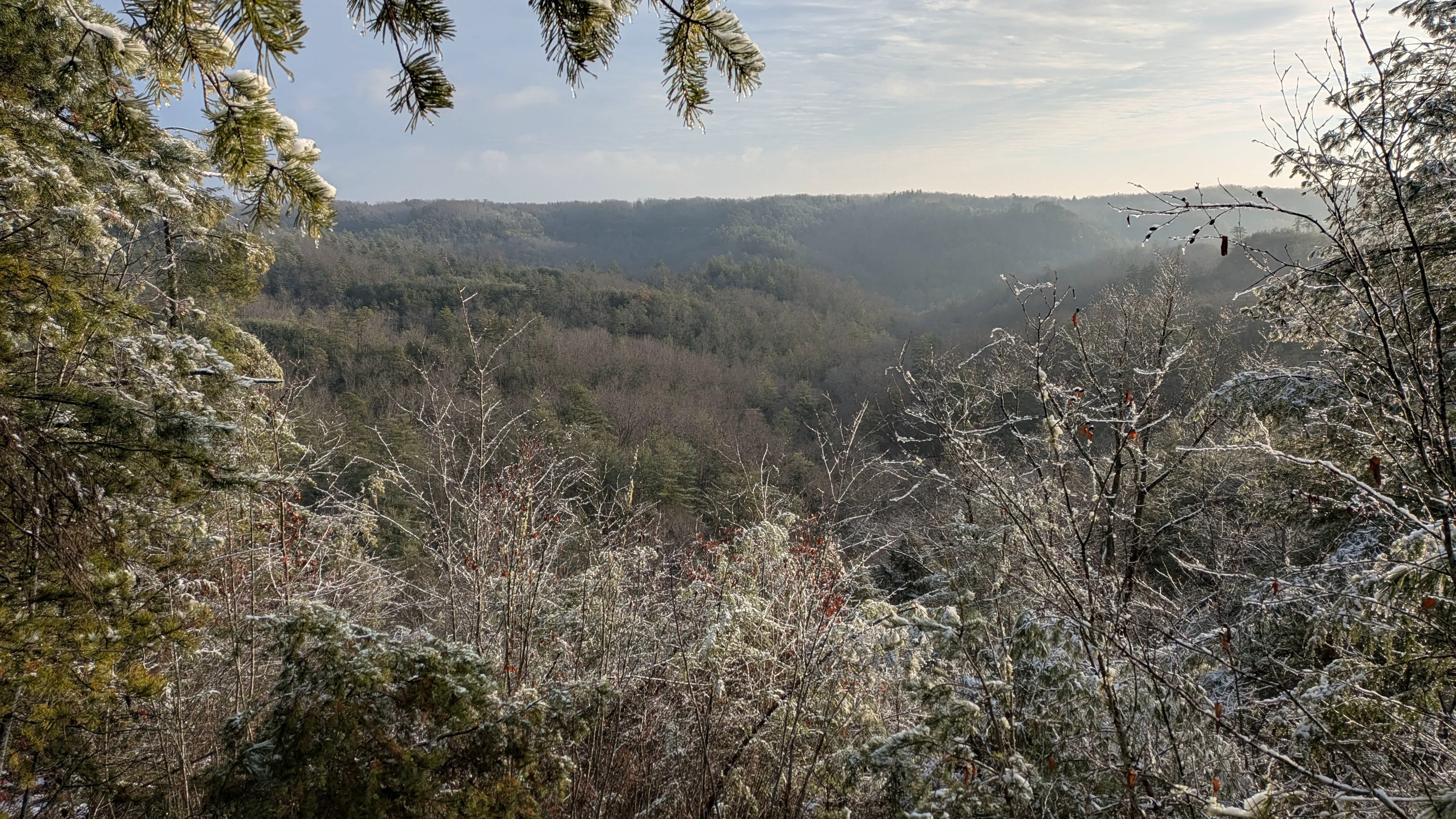
Now starting a half hour late, I set off with a brisk 3.2 mph pace. I was able to enjoy the perfect conditions. A dry trail, pretty trees, and no snow on the ground for me to clear away for the tent.
Around 45 minutes into walking, I found a series of three campsites just off the trail. Picking the one with the best view, I had my tent setup before 5:30. Snow had started falling, but it only dusted the ground.
Even though my cold hands would have enjoyed a hot dinner, I wasn’t quite hungry enough to sit in the cold for another 20 minutes. So I ate the smoked salmon, hung my bear bag, and went to bed.
Falling asleep quickly is a gift of mine, so I wasn’t surprised to find out that I was asleep before 6:30 pm.
I woke up at an alarm at 11:00 pm that I set as a reminder to let my fiancee know that I was alive and warm. And then again at 3:30 am when I a group of brave runners went by with headlamps.
The Morning Trail Link to The Morning Trail
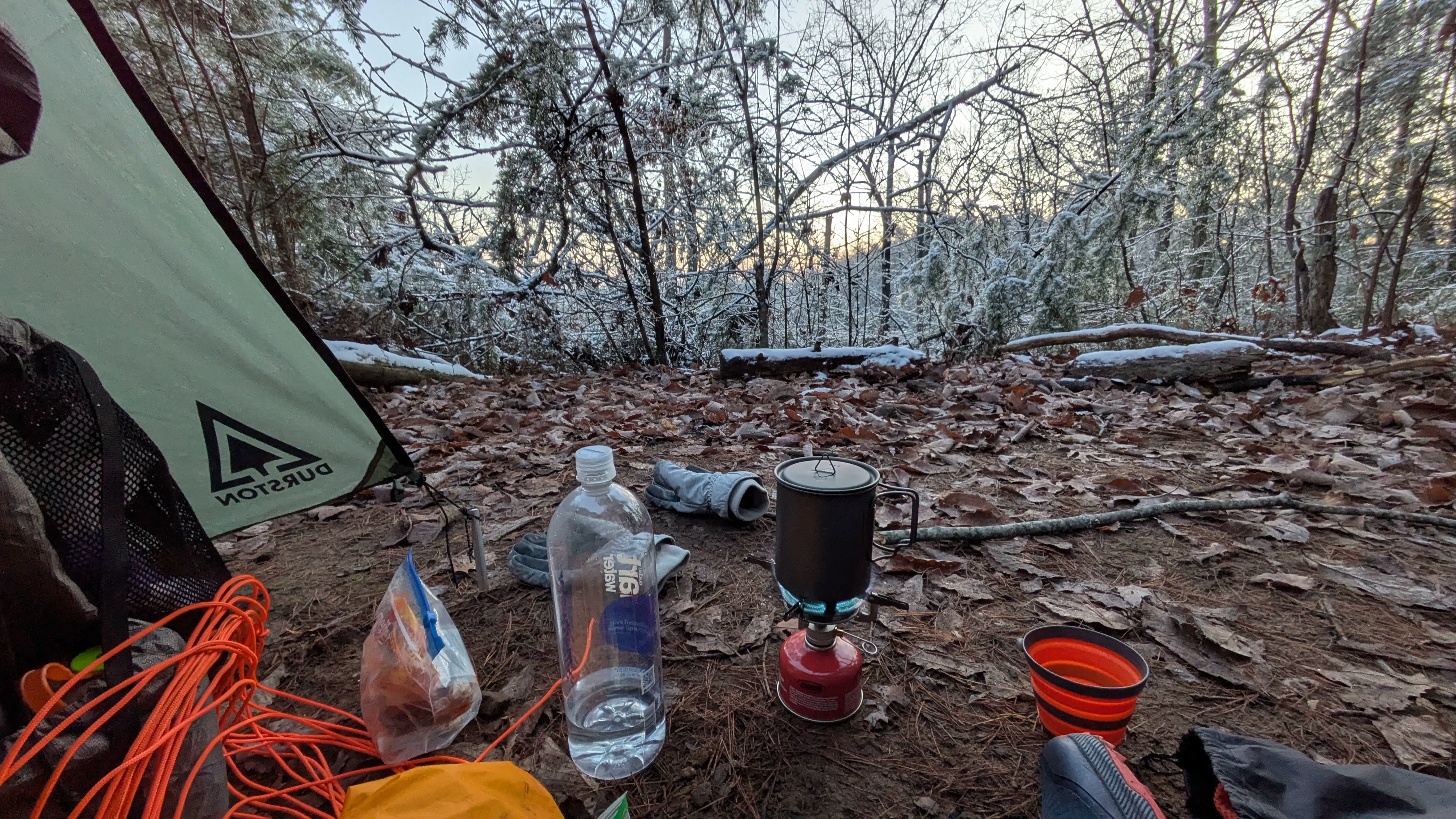
When I woke up, there was quite a bit of frost on the tent. I had forgotten to open both of the tent vents, so the moisture of my breath froze to the tent sides. Packing the tent left me with damp gloves, so I’ll need to remember to take off my gloves when packing my tent in the future.
Thankfully, not all of the winter camping tips were forgotten. I remembered to sleep with my fuel canister, so I was able to boil water for coffee and breakfast without any problems.
While the trip was mostly a test trip, I was also looking for a quiet time outside. Watching the sunrise twinkle off the snow covered trees while drinking coffee under a blanket was exactly the moment of peace that I was looking for.
The rest of the morning was mostly uneventful. I met someone who was also backpacking, and then met them again when I had to backtrack after a wrong turn. Which I proceeded to do quite a few times because holding my phone was difficult. The damp gloves meant my hands had a hard time getting warm, and the air was too cold for me to walk without them. Which means that I’m now looking into smart watches. If anyone has tips for good backpacking watches, send me a message at [email protected].
I was back at my car around 9:30 am, but the cold weather took another shot at my car. The battery in my keyfob is apparently too old for the cold, so all of the remote functions stopped working. To make matters worse, the manual door lock was frozen and I couldn’t get the key inside. Thankfully, placing my keyfob in my armpit for 10 minutes warmed it up enough to work.
On my way out, I stopped at Miguels to get a Christmas gift for my brother. It was hard not to notice the construction going on at Miguels. I’m looking forward to seeing what they’re building the next time I climb in The Red.
Reflection Link to Reflection
Other than the technical difficulties with my car, the trip was pretty smooth. The outdoor temperature didn’t drop below 27℉ (I carry a backpacking thermometer). Right at the limit for my Zenbivy quilt.
And the Zenbivy was fantastic, though I could definitely tell that I was at its limit. If I decide to go for an early February start of the AT, I’ll be sure to pick up a 0℉ light quilt. Since this hike, I’ve already had to cancel one trip due to the weather being too cold at night. If I want to make it through a 10℉ night, I might be okay with a fleece liner. Anything colder and it would probably be dangerous.
Wet gloves were pain point for me, so I’m going to need to figure out something else. I’m considering switching to a two layer system: light running gloves as a liner, and homemade waterproof dyneema mittens as the shell. If I end up making these, I’ll be sure to post the pattern and tips for making them.
Making wrong turns on trail is something that happens to me pretty frequently, so it might be time to look into smart watches. As I said earlier, my inbox is open to suggestions. However, I just got a Garmin InReach Mini 2, which has offline mapping capabilities. On my next trip, I’ll load that up with the map and see if that mitigates the issue without putting something on my wrist.
Overall, I thoroughly enjoyed this one-night trip in Daniel Boone National Forest. It was peaceful, easy to plan, easy to hike, and more relaxing than I could have hoped.
Winter Backpacking - Rush Ridge to Hansons Point
© Joey | CC BY-SA 4.0